Stephanie Granger: Using Satellite Data to Monitor Drought
Water Wise
As California struggles through one of its worst droughts on record, Stephanie Granger (MS, Information Science, 2008) needs only to cast her eyes skyward for help. But she’s not just on the lookout for rain clouds.
The senior scientist at NASA’s Jet Propulsion Laboratory (JPL) is putting her hopes on an array of satellites and other airborne technologies that are providing groundbreaking ways to measure fresh water availability on Earth, not just in California, but also in the Southwest and the parched agricultural regions of Africa. This data could, in turn, help water managers better monitor and apportion the planet’s most precious resource.
“Over the last 20 years, we’ve see more droughts, not only in California but in the entire United States,” says Granger, who is JPL’s liaison to water decision makers, particularly in the Golden State. “We really need better information—more cohesive information—to understand the characteristics of drought so we can better plan and mitigate for its impacts.”
Since 2010, she’s worked closely with the California Department of Water Resources (DWR) to identify “pain points,” or areas in which satellites—or remote sensing—can provide new photographic data and better understandings of the challenges at hand.
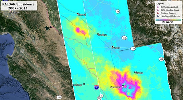
One area of concern is land subsidence in the agriculturally rich Central Valley (to see an animated video of subsidence, click here). Land subsidence is when the ground surface drops due to excessive pumping of groundwater during drought years. The San Joaquin Valley has some of the greatest subsidence rates in the United States, up to 30 feet in places, according to DWR. That could adversely impact other water sources by changing the slope of streams, canals, and drains.
DWR recently signed a contract with NASA to provide satellite scrutiny of regional subsidence. While the technology does nothing to resolve the state’s three-year drought, it does create new touchstones by which to view the problem.
“If we can monitor the situation and keep an eye out for hot spots, that could allow us to work with water suppliers in the area to see if there are ways to deal with these hot spots,” says Jeanine Jones, interstate resources manager for DWR. “California, unlike other western states, does not regulate groundwater pumping, so there are limited regulatory tools.”
The JPL data, she adds, “is another tool in the toolbox. It provides earlier notification that a problem is looming. We appreciate Stephanie’s willingness to work with us and stay focused on what’s practical.”
NASA joined forces with DWR after receiving funding from the American Recovery and Reinvestment Act of 2009, part of which sought to spur technological advances in science.
Granger has met with water resource managers throughout the state, providing what she calls “Remote Sensing 101” presentations to audiences that in some cases aren’t sure what an agency famous for rocket science and space exploration has to do with life on Earth.
“There are a lot of misconceptions about JPL and NASA and what we do,” Granger says. “When people think of JPL, they think of Mars, and they don’t realize that we have robust Earth-science capabilities.”
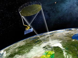
The space agency uses 16 satellites for such purposes, most with the ability to provide water data.
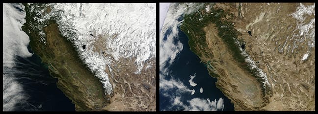
For more than a century, such data has largely been collected by taking manual readings of low-tech rain gauges. But the gauges haven’t been placed in the highest elevations of the Sierra Nevada, for example. Information from higher elevations would provide new and better data, particularly at a time when climate change is creating a range of new Earth impacts.
“As we start to see changes in the timing and amount of snow melt, it’s becoming more important to have information at higher elevations, and also at different times in the season,” Granger says. “This gives us a much broader perspective of overall change.
“In California, it’s been pretty dire this past year,” she adds. As for whether water shortages in the state suggest a new normal, “it’s really hard to say. Certainly, there are cycles, but what we’ve been seeing over the last few decades, it seems that this is becoming the new norm.”
New data is expected to tell a fuller story.
“This is groundbreaking stuff we’re doing in California,” says Michael Gunson, manager of the Global Change and Energy Program for JPL. “Even though remote sensing in its formal sense has been an element of the space program for more than 50 years, it’s only in the past couple of years that we’ve been using technologies to help with water resource applications. We’re trying to show how you can gain broader and better knowledge by using some of these new technologies. Stephanie’s experience and breadth of understanding about who we are at JPL has allowed her to tease out exactly where the high-payoff areas are so that we can help California.”
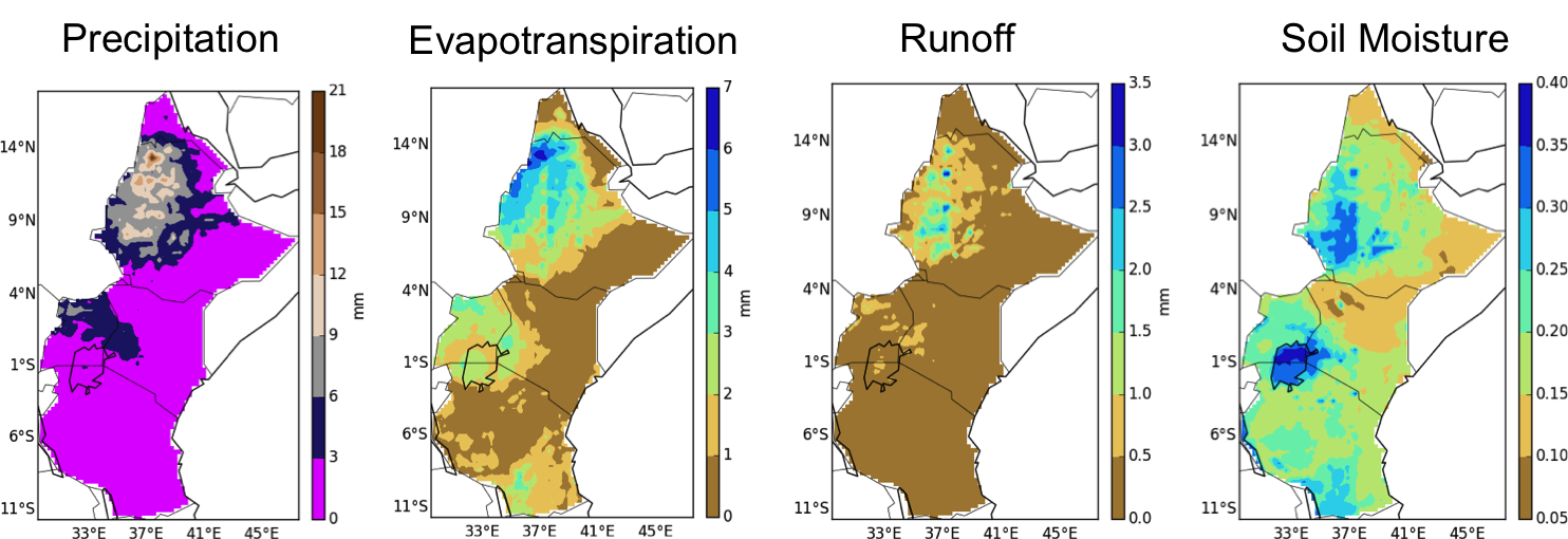
JPL began piloting remote sensing in California in 2013, and then cast satellites’ eyes on the Southwest. Remote sensing will continue until 2016 in Kenya, where Granger is leading the efforts. Other drought-related programs are underway. NASA is about to launch the SMAP (Soil Moisture Active Passive) Observatory, a satellite that will provide soil moisture readings from space. Resulting data will provide more drought monitoring capabilities.
Another effort, the Airborne Snow Observatory, involves flying an airplane over mountain watersheds in California and Colorado. That project is designed to produce the most accurate measurements to date on how much water they hold. More than 1.5 billion people around the world depend on snowmelt for their water supply, according to JPL.
In February, NASA launched the Global Precipitation Measurement Observatory, a satellite that provides three-dimensional views of precipitation all the way to the Earth’s surface.
“We’ll have precipitation estimates everywhere in the world every three hours,” says Gail Skofronick Jackson, project manager for NASA’s Goddard Space Flight Center in Maryland. “That’s really good for predicting floods, droughts, landslides, and hurricane tracking. If you can predict droughts in places where it matters, in terms of agriculture, you can have early famine warnings.”
The efforts are among the first attempts that NASA has made to share its vast trove of scientific data with non-scientists. Granger is at the forefront.
“Stephanie is one of a fairly small number of NASA scientists who interact with people in the real world and help to develop practical applications for what is otherwise very science-based research,” Jones says.
Adds Granger: “The challenge really is in bridging the divide between research and operational use. It takes time and frequent interaction with people. This is a first step in a much longer process. We need to continue to work with the water management community to co-develop solutions to some of the challenges.”
Granger, for her part, has been working with water managers since 2009. “It’s about building relationships,” she says. “They’re educating us, and vice versa. What we’re doing is learning about the decision-making process, which is very difficult. It’s not a clear path. We ask, ‘What keeps water managers up at night?’”
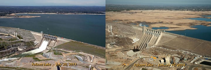
That’s not difficult to discern. The Sacramento and San Joaquin watersheds, which Jones calls “the workhorses in terms of water supply for much of the state,” are showing the effects of what could be California’s third or fourth driest year on record.
For Granger, who has worked at JPL in various capacities since 1982, the challenges are compelling. She’s long been interested in environmental sustainability, back to the days when her botanist mother introduced her to Rachel Carson’s Silent Spring. The book, which addresses the impact of pesticides on the Earth, was one of the country’s first environmental treatises when it was released in 1962. The work inspired a movement that led to the creation of the Environmental Protection Agency.
Granger, who initially considered becoming a teacher, says her science career “just kind of happened.” She said one of her professors at the University of Redlands encouraged her to enroll at CGU for her master’s degree at the Center for Information Systems & Technology.
“CGU offered me a cutting-edge curriculum that was up to date with current advances in information systems and technology and challenged us to think about the future of technology,” she said.
Since she left, Granger has devoted her career to using technology and science to advance water issues. Water, she notes, is too easily taken for granted.
While 89 percent of Californians say drought is a major problem in a recent poll, only 16 percent of respondents report that it affects them to “a major degree,” according to results that were publicized in the Los Angeles Times.
“We turn on the tap and water comes out,” Granger says. “Especially in California, a lot of people just don’t have an appreciation for the long road that water travels. If you go to school here, we all learn about missions when we’re in the fourth grade, but I really think we ought to learn about the Bay Delta and the Colorado River. Then, I think we would build a greater appreciation.”
Until then, here’s hoping for rain.