Eyes in the Skies
Professor Andrew Marx uses satellite imagery to help stop human rights violations across the globe
With the help of NASA satellites orbiting more than 400 miles above the Earth, Andrew Marx works to reduce human suffering.
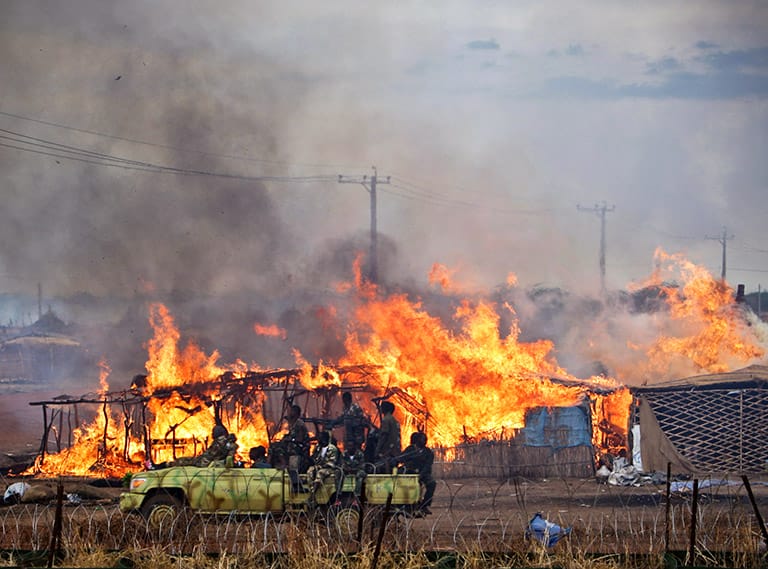
An assistant professor in CGU’s Center for Information Systems & Technology, Marx teaches students a new method he developed of using satellite imagery to more effectively detect mass killings, genocidal attacks, and war crimes in far-flung countries. His technique has been able to successfully document thousands of villages that were destroyed in the Darfur region of western Sudan.
This research suggests a cost-effective, early-warning system capable of assisting humanitarian efforts in stopping—and preventing—human rights violations in the most inaccessible regions of the globe.
“The goal of my research is to shed light into the darkest corners of the world—remote villages in conflict areas that are at risk for human rights violations,” Marx said. “When these villages are destroyed with no survivors, the international community never knows and perpetrators aren’t being held responsible.”
Foreign Affairs
Marx’s interests have often intersected with international affairs and humanitarian interests.
He has a PhD in geographical sciences from the University of Maryland and a master’s degree in urban planning from the University of California, Berkeley. A 1997 graduate of the U.S. Air Force. Academy, Marx’s first assignment included participation in 1999’s Operation Allied Force, NATO airstrikes that sought to stop ethnic cleansing in Kosovo. Marx later served as a foreign affairs analyst for the U.S. Department of State from 2006 to February 2015.

In 2013, he was a visiting fellow at the U.S. Holocaust Memorial Museum’s Simon-Skjodt Center for the Prevention of Genocide in Washington, D.C. As a fellow, Marx looked at existing methods that human rights organizations employed when utilizing satellite imagery to verify reports of mass human rights violations.
But the current practice is fraught with problems. Organizations often must first receive an unconfirmed report of a violation taken place in a particular area. Next, they follow up by ordering expensive high-resolution commercial satellite imagery, and then hire a specially trained analyst to interpret the images that may confirm the initial reports. This practice is considered reactive and costly.
Marx looked for a better way.
An Exciting Tool
Marx theorized that the destruction of villages by burning—a tactic employed in some mass atrocity situations—altered the landscape, changing the way it reflected electromagnetic radiation, such as solar energy. He proposed that NASA satellites were capable of detecting these changes.
His theory was correct.
Using approximately 650 medium-resolution Landsat images, Marx documented 2,666 villages that were destroyed in the Darfur region of Sudan between 2002 and 2008. Rebel groups and the Sudanese government have been fighting since 2003, resulting in the deaths of thousands of civilians, the burning of thousands of villages, and a major humanitarian crisis.
Marx’s research also revealed more specific and accurate patterns of violence than were previously documented. For example, by combining geographic information with timestamp data, he was able to determine which specific rebel groups were most likely responsible for certain attacks during periods of ceasefires. He was also able to track destroyed villages on a roughly biweekly instead of an annual basis, which is more typical.
“Dr. Marx is developing an exciting tool for obtaining actionable evidence of when and where attacks are targeting civilian populations,” Simon-Skjodt Center Director Cameron Hudson said.
No Dark Corners
The detection of human rights violations is important because it provides the verification that is often needed by governments and nongovernmental organizations before they take action, such as prosecuting the
perpetrators of these crimes.
NASA imagery offers several advantages. The images are free and publicly available through the U.S. Geologic Survey, often within 24 hours of when they are taken. Commercial satellite images offer better resolution, but they cover less territory and only capture images after a violation has been reported. NASA images, however, are constantly capturing images of large areas.
Consequently, Marx’s methodology could facilitate near real-time monitoring of large areas at-risk for mass human rights violations and allow faster response times by authorities.
Marx has now expanded that research to other countries. In Syria, a country that’s been crippled by a brutal civil war since 2011, Marx documented the use of “barrel-bombs” and other large-scale, indiscriminate weapons used against residential neighborhoods in Damascus and Aleppo.
“Our goal is to provide research that empowers international organizations and governments to detect, prosecute, and ultimately prevent the worst human rights violations,” he said. “We want to ensure that there are no dark corners of the world left where these violations can occur undetected and unpunished.”
To view an illustration of Andrew Marx’s research, click on the video below. It depicts the Darfur villages that were detected as burned between 2003 and 2008, using data derived from the historical archive of NASA’s Landsat ETM+ satellite. (Video courtesy of the U.S. Holocaust Memorial Museum’s Simon-Skjodt Center for the Prevention of Genocide)